
The Ultimate Guide to Botswana's Makgadikgadi
When it comes to Botswana, the Makgadikgadi usually isn’t the first place people think of, let alone know how to pronounce (think MUCK-KUD-EE-KUD-EE).
Yet, a decade ago, when considering whether to skip Botswana and just keep travelling through Namibia’s Caprivi strip (now the Zambezi Region) and head straight for Victoria Falls, the Makgadikgadi was what inspired me to point my hitch-hiking thumb upwards, and detour across the Mohembo border post, south into Botswana.
See, years ago, I’d been to Bolivia’s Salar de Uyuni, a blinding white expanse of salt, fringed with volcanoes and cacti - which draws in throngs of backpackers travelling along the Andres. As it turns out, I’d loved it. So, when I found out that Botswana had the world’s largest salt pans complex, I decided I had to go.
Reading about the salt pans in my guide book reminded me that I’d once seen a Top Gear special filmed in Botswana, which took Jeremy Clarkson and crew via the Makgadikgadi’s Kubu Island. A rocky outcrop on the edge of the salt pans, littered in baobabs where sunsets wash over the island’s salty shores like blazing tsunamis.
They say comparison is the thief of all joy, but I still wanted to see how the the Makgadikgadi sized up against the Salar de Uyuni. And so I went.
On my first trip to the Makgadikgadi, the logistics were the first challenge.
How do we even get out there? Was there a bus? Could we hire a driver?
This is the thing with Botswana. Its lack of shiny infrastructure is it’s charm.
You need a bit of clever planning to make things happen. As well as an idea of where exactly in the Makgadikgadi area you want to go, and what you’ll get once you’re there.
Fear not, I’m here to help.
Check out this quick intro video, and then, read on below:
AREAS OF THE MAKGADIKGADI
The Makgadikgadi is actually a series of salt pans and grasslands, stitched together, covering an area roughly the same size as Switzerland. Beyond the salt pans themselves, there’s also the Boteti River. The Boteti not only forms the western boundary for the Makgadikgadi National Park, but also provides some of the only water for wildlife in the area during the dry season.
All these areas are interlinked by wildlife migrations which impact where you’ll find what, and when in the year.

Sua Pan
SUA PAN
This salt pan is the furthest east in the Makgadikgadi, and also the wettest spot to try and hop out into the pans from. The closest town for access into Sua Pan is Nata, which sits at a giant t-intersection, where you can travel north to Kasane (Chobe), south to Gaborone/Francistown, or west towards Maun (for the Okavango Delta and Moremi). On the edge of Sua Pan sits the Nata Bird Sanctuary, which is easily accessible by Nata with your own car, or via a sunset trip to the bird hide (which faces west into the sunset) with one of the lodges in the Nata area, such as Nata Lodge. If Sua Pan is particularly dry, this is the easiest access point to get a feel for the expanse of the salt pans. If the pans are wet, Sua Pan can get quite deep with water, where you’ll have the impression of being in the bird-filled wetland instead. Sua Pan stays wet for longer than Ntwetwe after the rainy season ends, primarily as two waterways feed into the pan : the Motsetse and the Nata Rivers.
THE FOCUS: Birdlife at the Nata Bird Sanctuary, as well as the bird hide for views out towards the salt pans with a cold drink in hand.
Wading out into Sua Pan from Nata Sanctuary’s bird hide in July

The Nata Sanctuary bird hide looks out onto Sua Pan which fills with water seasonally

That time I got asked to pull out a couple of stuck self-drivers in Sua Pan in green season
“If Sua Pan is particularly dry, this is the easiest access point to get a feel for the expanse of the salt pans”

Skydiving over Sua Pan from the Nata Sanctuary during the annual Makgadikgadi Epic (dates change annually)

Kubu Island
KUBU ISLAND
Ntwetwe and Sua Pans are separated by a thin peninsula of grass land which cuts between the two pans in a north to south direction for about 90kms. At the bottom of this peninsula sits Kubu Island. A rocky outcrop covered in boulders and baobabs, with great views out around the surrounding landscape. Being down at Kubu Island, it’s possible you’ll see a springbok or two on the way in, and even springhares (nicknamed the African kangaroo) jumping around at night. Kubu Island is to the Makgadikgadi what the Isla de Pescados is to the Salar de Uyuni. An island adrift in a sea of salt, covered in succulents (just trade the cacti for baobabs).
If you have a proper 4x4 and visit during the drier months, Kubu Island is also accessible by driving across the pans from Gweta (a trip of roughly 100kms) though much of this road follows a veterinary fence, with stretches driven in the open pan.
THE FOCUS: Exploring ancient baobabs, and climbing over boulders for views across the salt pans complex.

Sitting at the edge of Kubu Island, Makgadikgadi Salt Pans

Sunset at the Southern Islands

The view from the top of Kubu Island

Salt Pans sleep outs off the Southern Islands

Salt Pans sleep outs a couple of kms off the ‘coast’ of Kubu Island

Sunset at the Southern Islands

Starscapes at a secret baobab-covered island near(ish) Kubu

Ntwetwe Pan
NTWETWE PAN
This salt pan is the more often visited for pans sleep-outs due to the three luxury camps on the pan’s edge (Jack’s Camp, Camp Kalahari & San Camp) as well as the more affordable Planet Baobab near Gweta, which organises trips out to Ntwetwe Pan to visit colonies of habituated meerkats, and sleep outs under the stars. Ntwetwe Pan borders the Makgadikgadi Pans National Park itself, and this area forms the summer home for one of Botswana’s zebra migrations (roughly December - March)
THE FOCUS: As a lot of Ntwetwe Pan is included in the private concession of CT11, it’s often only explored by travellers staying at one of the safari camps listed above. As these properties include all activities (with the exception of Planet Baobab), the focus is on quad biking, salt pans sleep-outs, night drives searching for desert-adapted wildlife and hanging out with habituated meerkats. Also possible are nature walks with the Khoi San people (made famous by the 1980 comedy ‘The Gods Must Be Crazy’) for learning about this hunter-gatherer tribe’s millenia-old techniques for desert survival.

Game driving from Jack’s Camp

Ntwetwe Pan is the perfect spot to find nocturnal mammals on night drives, like this Cape Fox, spotted at San Camp

Brown hyenas at sunset on Ntwetwe Pan

San Camp on the edge of the Makgadikgadi Salt Pans
“On Ntwetwe Pan, the focus is on quad biking, salt pans sleep-outs, night drives searching for desert-adapted wildlife & hanging out with habituated meerkats”

Walks with the Khoi San

When you’ve just sat down for lunch and the vultures start eyeing off your snacks

Salt Pans Sunsets

The undisputed stars of Ntwetwe Pan : the meerkats

Tree Island & Njuca Hills
TREE ISLAND & NJUCA HILLS
Tree Island and Njuca Hills are two remote campsites, situated near the edge of Ntwetwe Pans in the short grasslands of the Makgadikgadi Pans National Park. Both sites are most interesting after the first rains in Botswana (anywhere from end of October to end of December) when the zebras start migrating back to the salt pans from the Boteti River. Here, timing is everything, and with the rains being impossible to predict, it’s best to weigh anchor here for the total seclusion of this spot, where the closest other humans are bound to be at least three hours drive away down sandy tracks. If you get your timing right, however, the experience can be phenomenal, with thousands of zebra shuffling single file past your campsite and no need to go on a game drive to enjoy what the area has to offer.
Both campsites offer some shade with terminalia trees in an otherwise open landscape. I camped here by myself for a few days over New Years Eve 2018/2019 and didn’t even see another set of tyre tracks, let alone another human being in the time I was camped out. I had the zebra migration passing through my campsite day and night, and heard the honking of flamingoes migrating overhead in the evening while sitting by the campfire. To top it off, I found an aardwolf I could finally photograph (safari stardust!) and right as the clock struck New Year’s Day 2019, a big male lion started roaring a few kilometres off to lull me to sleep.
During the rainy season, the tracks here can get quite boggy, so driving should be done mindfully to avoid either getting stuck, or squashing bullfrogs and terrapins lurking in the puddles. Visiting during the drier winter months, a few nearby seasonal pans may still hold some water, and it’s possible to find a few zebras scattered here and there, but not in the same numbers as during the green season (November - March).
THE FOCUS: Total remote seclusion for chilling out under the terminalias with a great bunch of mates at the edge of a small salt pan, or for trying your luck at catching the zebra migration, as well as desert-adapted mammals and a whole host of reptiles after the first rains.

Some of the less-waterlogged Makgadikgadi tracks in rainy season

Stripes and storm clouds at Tree Island
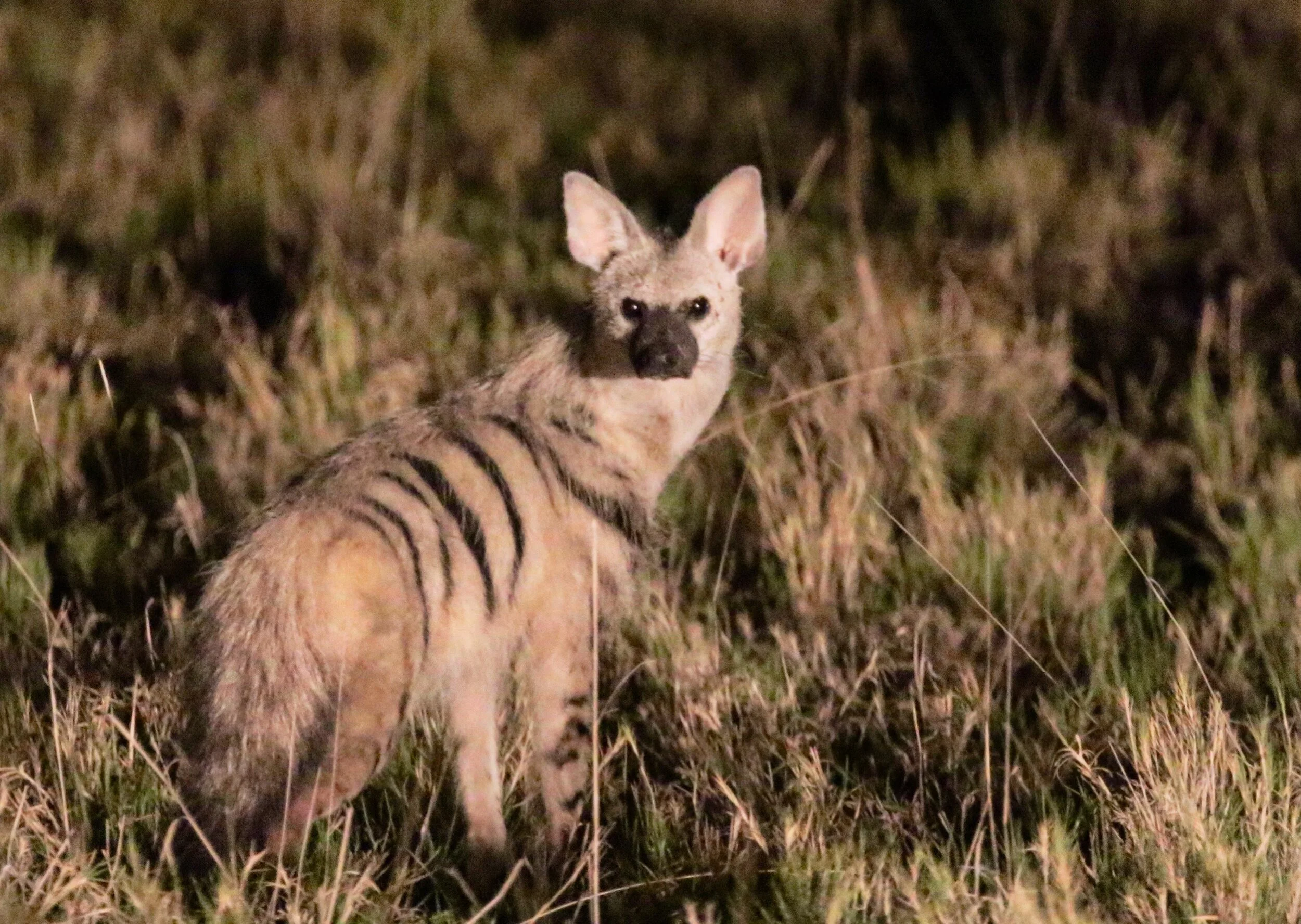
A once-in-a-lifetime sighting of an aardwolf near Tree Island

The weird and wonderful creatures of the Makgadikgadi come out with the rains

Away from the pans, tracks get sandier and palm trees more abundant

The zebra migration passing through the grasslands by Tree Island campsite

Boteti River
THE BOTETI RIVER
This is one of my favourite places in Botswana, and with only three lodges in the area, it still gets very few visitors, despite being less than 2 hours drive from Maun (in Botswana terms, that’s close!).
The Boteti River forms the western boundary of the Makgadikgadi Pans National Park, and is the only permanent water for hundreds of kilometres around in the dry season. The Boteti River is fed by water from the Okavango Delta, so depending on how much water is coming through the delta, the Boteti may be flowing, or may shrink back to a series of waterholes along the dry riverbed.
The Boteti River is the home of one of Botswana’s zebra migrations, and usually hosts plenty of zebras from around May / June to October (or whenever the first rains arrive). The Boteti River has a small escarpment to it’s western side, along which the lodges are located with a bird’s eye view into the park. The real drawcard here is to sit back, relax and just watch the water’s edge, rather than spending hours driving along the river - although the option exists to do that too.
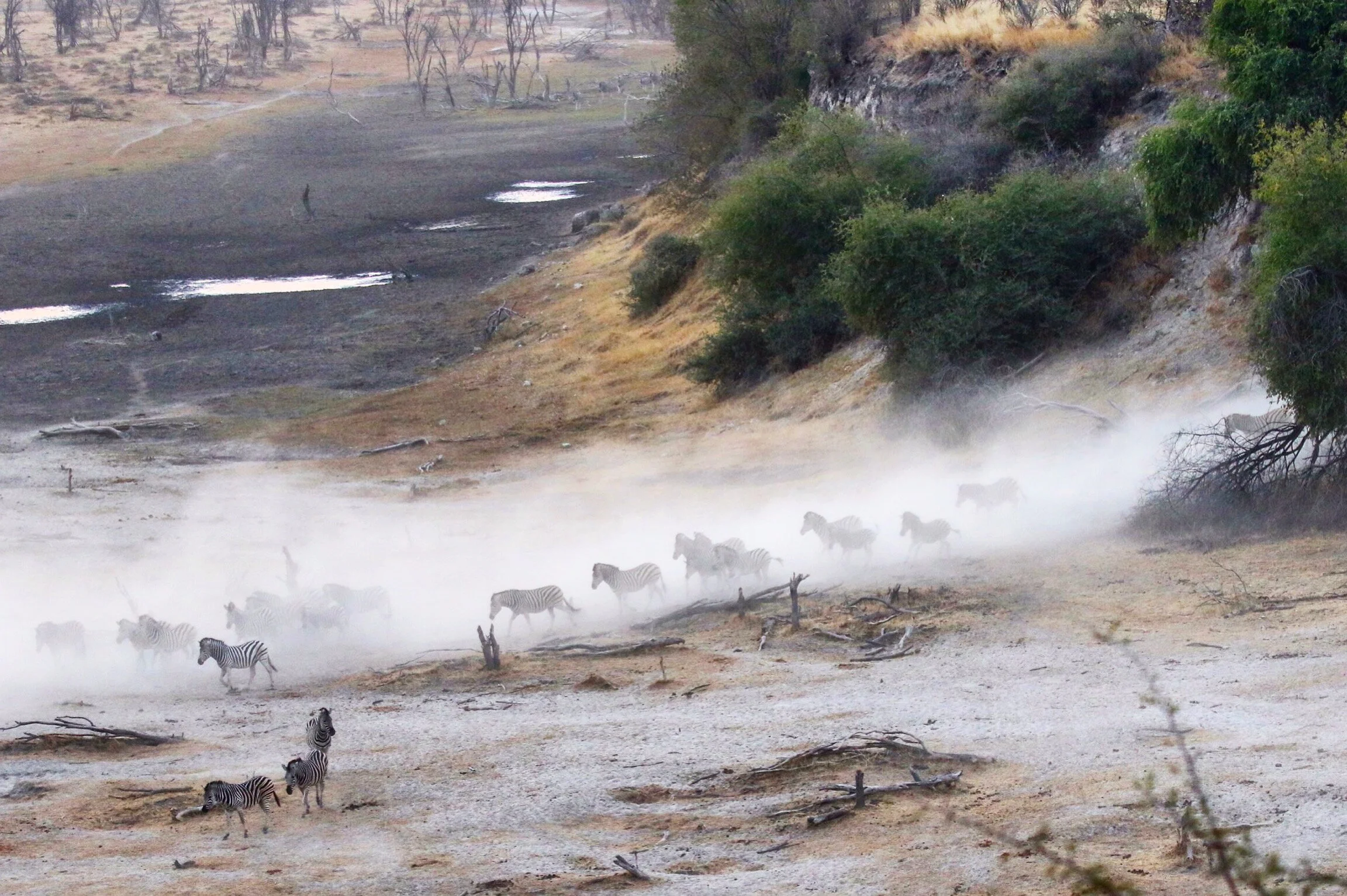
The lion population in the area has been improving in recent years, however as there are villages along the Boteti River, the local cattle often competes with wildlife for access to grazing and water, so human vs wildlife conflict can be a sometimes reality in the area. In really dry months, the steep river banks cause herds of zebra coming for water to kick up massive clouds of dust which creates spectacular silhouettes at sunset.
THE FOCUS: This area is popular with elephant bulls, as well as the zebra and wildebeest that visit in huge numbers in drier months. The Boteti River is a true armchair safari, and the river itself is a great spot to look out for plenty of raptors, as well as the occasional predator.
Thirsty zebras looking for water in the dry Boteti Riverbed

An elephant bull chases a domestic cow away from water as the competition for resources in the dry season heats up
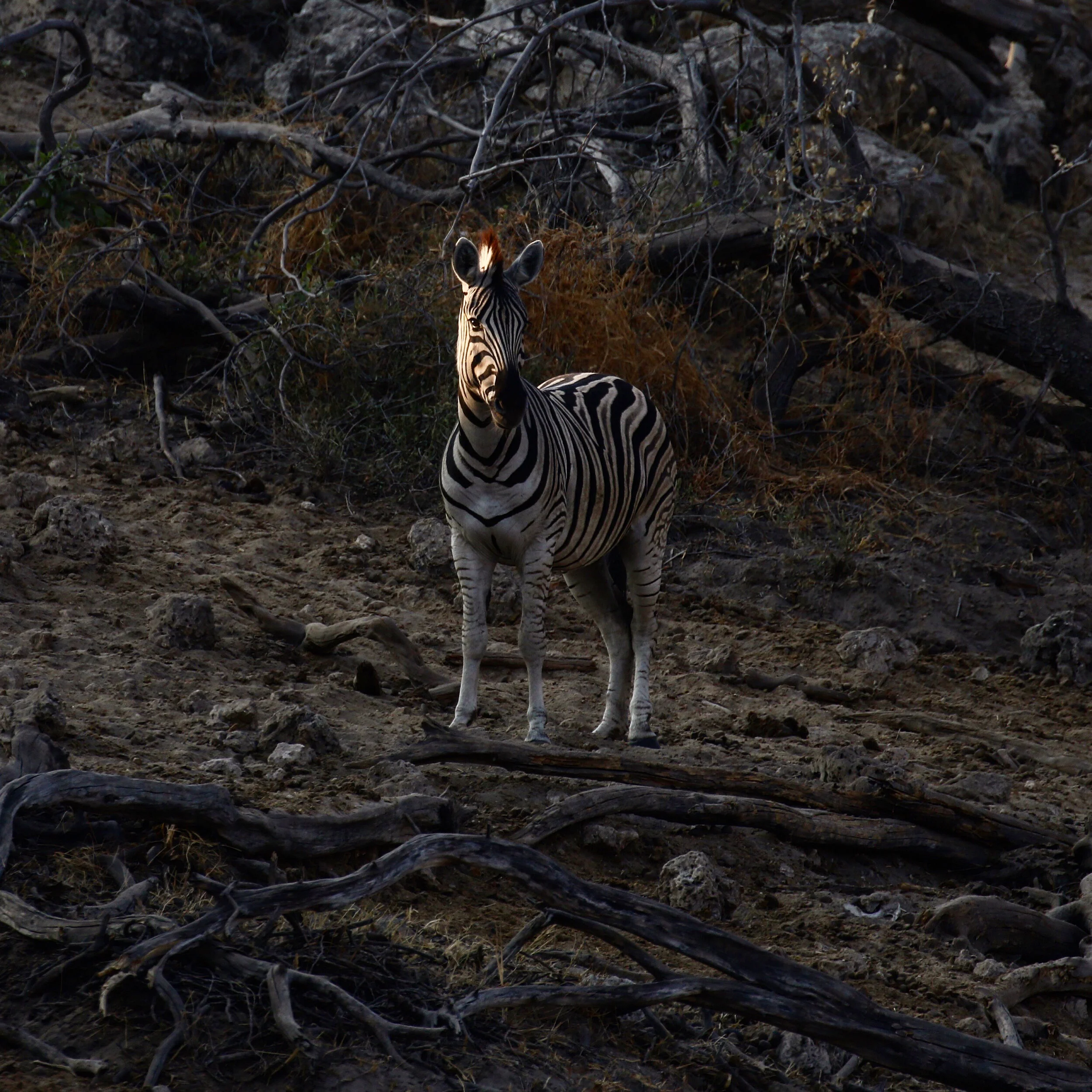
From May to October, zebras can often be found by the Boteti’s edge

When the Boteti River starts shrinking back, fresh graze sprouts on newly-revealed floodplains, drawing in plenty of ungulates
“Under-visited, but with plenty to appreciate, the Boteti River is an armchair safari enthusiast’s dream”

Dusty silhouttes catching fire at sunset

The Boteti River’s water draws in plenty of elephant bulls who like to hang out on the river year-round

The lion population on the Boteti has been growing in recent years

With views directly into the Makgadikgadi Pans National Park, the lodges along the Boteti River provide the perfect armchair safari
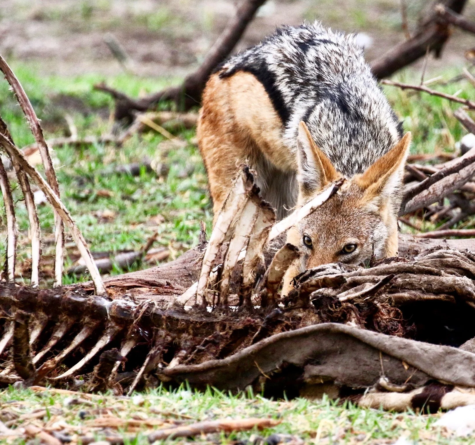
A black backed jackal takes advantage of zebra scraps by the water’s edge
ACCESS TO THE MAKGADIKGADI
ON PUBLIC TRANSPORT
Getting to the Makgadikgadi on public transport means needing to get to the closest point that you can find a driver to take you out there. There are no gleaming tar roads to the Makgadikgadi’s doorstep - but this also means that once you get there, you won’t be competing with tour buses either. And this is the whole reason to go.
Buses head to Nata from Maun, Kasane and Gaborone (via Francistown) and you can jump off here and stay at one of the local guests houses to book a trip out to Nata Sanctuary. For Ntwetwe Pan, buses travel between Francistown and Maun via Gweta and Nata. The jumping off point here would be Gweta for Planet Baobab or Gweta Lodge, both of whom offer trips into Ntwetwe Pan, which can take up to 4 hrs to access on sandy tracks by safari vehicle, depending on the time of year.
For the Boteti River, buses between Gaborone and Maun go via Khumaga, where you can jump off in order to get to a safari camp for activities in the Makgadikgadi National Park. The most affordable choice here would be the Boteti River Camp for booking accommodation & activities in the park.
Catching the bus might seem the most affordable option on surface-value, however as the only way to properly explore the pans is with a vehicle, the cost of a lodge stay and activities might well outstrip the cost of renting a fully-equipped 4x4 and going at it on your own - depending on your level of confidence at engaging low range.
If you find yourself with spare time in Gweta, there’s the occassional brightly painted house to be found when trawling the sandy tracks around town
WITH YOUR OWN 4X4
With a 4x4, the options are endless, but understanding where in the pans to go, and at what time of year, with what to expect is the biggest challenge.
First things first, if you decide to go in a 4x4 you should make sure you have recovery equipment (tow rope, hi-lift jack, shovel and even spare firewood to be attached to the tyres with ratchet straps to un-bog yourself if you get stuck on the pans). Always follow existing tracks on the pans, to avoid leaving extra tracks. This is also the best way of gauging how wet the pans may be underneath, in case you encounter recent tracks that have been churned up - which is a good cue to slow down your speed and avoiding losing control of the car in case of boggy conditions. If you are renting a 4x4 and don’t know anyone in Botswana, make sure the rental comes with a satellite phone and reliable contact for assistance in case of getting stuck.
The biggest rule? Always, ALWAYS take everything with you when you pack up camp, and use a shovel to cover up after ‘comfort stops’ (polite bush-speak for needing the toilet)
Never drive into the pans in the wet season, and always double-check conditions locally where possible, if heading into the pans earlier than June, or late in October, in case of any localised rain making driving sticky.
On the other hand, having your own 4x4 in the Makgadikgadi is the absolute epitome of freedom. With the right conditions, you can cross the pans from Gweta across to Kubu Island, and find alternative tracks up to Nata along the end of Sua Pan, avoiding the grasslands. You can sleep out under the stars, outside the tent, and gather your mates around a campfire for endless chats and wine refills from the cooler box. Just make sure you have enough water for cooking, washing up, drinking, and scrubbing the salt off your face before you go to sleep.
I highly recommend downloading Tracks4Africa on your smartphone before you go. The app works without needing phone signal and will help you track exactly where you are at all times. It’s knowledge of tracks out in the Makgadikgadi is not always spot on - so the best bet is to use it as a rough guide to figure out your general orientation and go from there. If you really get stuck, remember most iphones have an inbuilt compass that can give you the general orientation you need to get back to the tar. At the edge of the pans, the tracks spiral out like spider webs between cattle posts, and don’t necessarily head anywhere definite. Knowing your general orientation here is often the trick to picking out the right track.
WITH A SAFARI OPERATOR
This part of Botswana can be visited on a mobile safari (usually departing from Maun) where costs will be most affordable if there’s a group of you, to bring costs down. Most mobile safari operators in Botswana don’t include the Makgadikgadi as standard on their ‘set departures’ which is a pity - but mostly down to demand for the northern parks (like Moremi, Savute, Chobe etc.) being higher.
The advantage to going with a mobile safari operator, is that it’s easier to combine different parts of the Makgadikgadi, than if you book a fly-in safari. You can then include the Boteti River with Kubu Island, traversing the salt pans in between, and even consider making your way back to Maun via a detour to Nxai Pan national park.
The other option is to book a fly-in safari to Ntwetwe Pan, or to the Boteti River (for Leroo la Tau). On the Boteti, both Meno a Kwena & Boteti River Camp offer road transfers from Maun. Planet Baobab or Gweta Lodge can also be reached by road transfer.
